

Wildfire risk assessment: protecting UK sites from grass, heath and moorland fires
A wildfire risk assessment for a UK site looks at the open land around it, what will burn and how close it is, how a fire could start, who and what is at risk, and what you will do on high fire danger days and if a fire comes. Keep a mown buffer and firebreak at the boundary, keep stores back from the fence, control machinery, hot work and visitors in dry weather, plan routes out and meet the fire service, and make sure smoke on the land next door is seen in minutes, day or night.

Last updated 2 November 2026. 2026 was the year wildfire stopped being something that happened somewhere else. In England, government figures show 1,354 wildfires between January and August, up from 957 in the same months of 2025, and fire services sent more fire engines to wildfires in those eight months than in any full year on record. Fires burned through grassland on the Gower in April, across moorland in the Peak District and through heath and forest in the Cairngorms, at Dunwich Heath in Suffolk and in the New Forest in high summer. And again and again, fires that started on open land reached something built: a solar farm in Nottinghamshire, an industrial estate in Weston-super-Mare, a holiday park in Suffolk, and 19 homes in Stourbridge.
That is why more businesses, landowners and site managers are asking how to carry out a wildfire risk assessment. If your site sits next to grassland, heath, moorland, forest, dunes, farmland or rough ground, the biggest fire risk you face in a hot, dry summer may not be inside your fence at all. It may be the land next door, a dropped cigarette on the verge, a barbecue on the heath, a hot mower in the field or a fire set on purpose, and a wind that pushes the fire towards you.
This guide is for owners, managers and fire safety leads at sites near open land in the UK: solar farms, waste and recycling sites, quarries, holiday parks and campsites, golf courses, farms, industrial estates, utilities and estates. It explains what a wildfire is and how the UK measures them, what happened in 2026 and what ten real fires had in common, what the law and planning rules expect, and how to assess your own site step by step. It covers fuel and firebreaks, the ways fires start, fire danger days and how to step up your response, a wildfire emergency plan, helping the fire service find you and find water, smoke and business continuity, and what to do after a fire nearby. The final sections cover why fires on open land are so often seen late, and how AI smoke and intruder detection on the cameras you already have can make sure smoke at your boundary is seen in minutes rather than when it reaches the fence.
It is general guidance, not a fire risk assessment of your site. Your local fire and rescue service, a competent fire risk assessor and your insurer can help with your own premises, and we link to the original guidance and reports throughout so you can read them in full.
What is a wildfire?
In everyday speech a wildfire is any fire burning out of control in the countryside: grass, heath, moorland, gorse, forest, crops or peat. The organisations that count and fight them use more precise definitions, and they do not all use the same one, which matters when you compare figures.
The National Fire Chiefs Council (NFCC) defines a wildfire as any uncontrolled vegetation fire where a decision or action is needed about its suppression. It adds that a wildfire will meet one or more of these criteria: it covers at least one hectare (10,000 square metres), it has a sustained flame length of more than 1.5 metres, it needs at least four fire service appliances or resources, it needs resources committed for at least six hours, or it presents a serious threat to life, environment, property and infrastructure.
The government’s provisional wildfire statistics for England use a simpler measure: outdoor fires where more than 1,000 square metres of land was burned. And the incident-level outdoor fires dataset that sits behind many local figures does not define a wildfire at all, as its own guidance points out. So a news report about “grass fires”, a fire service figure for “wildfires” and a national count of large fires can all describe the same summer and give very different numbers.
For a site manager, the definitions matter less than the idea behind them. A wildfire is a fire on open land that spreads on its own, driven by fuel, weather and slope, and that people cannot simply walk up to and put out. Small grass fires become wildfires quickly on a dry, windy afternoon. The NFCC also warns that wildfires are now starting earlier in the season, lasting longer, and occurring almost anywhere in the country, including where countryside meets towns and businesses.
2026 in numbers
Analysis of the government’s provisional figures by the Moorland Association shows how sharply 2026 stood out in England. Between January and August there were 1,354 wildfires, against 957 in the same months of 2025. Of those, 468 burned more than 10,000 square metres, up from 243, so large fires made up 34.6% of the total compared with 25.4% a year earlier. Fire services used 12,125 appliances at wildfires in those eight months, more than in any previous full calendar year in the government series, including 2022 with 11,511. Seventeen people were taken to hospital, against seven in the whole of 2025. Large wildfires averaged 204 a year from 2021 to 2025, up 47% on the decade before. And the government notes its 2026 figures are provisional and may underestimate the true number.
The picture is similar elsewhere. The Global Wildfire Information System (GWIS) puts the area burned across the UK in 2026 at 28,299 hectares, the second highest on its record, which starts in 2012. The European Forest Fire Information System (EFFIS), which maps fires in a different way, ranks 2026 third, at 25,084 hectares. Senedd Research gives the same 28,299 hectares for the year to 1 September, and reports that Wales had four wildfire major incidents during its hottest summer and driest July on record. In 2025, Mid and West Wales Fire and Rescue Service says fire services across Wales attended 3,474 grass fires, a 275% rise on the year before, and 2,357 of them were deliberate. The Guardian, using PA analysis of fire service data, reported nearly 27,000 wildfires across England in 2025.
Fire services also fight a much larger number of small outdoor fires. Home Office figures for England in the year ending June 2026 show 91,487 secondary fires, generally small outdoor fires not involving people or property, and 6,485 outdoor primary fires, up 6.3% on the year before and 34% on ten years earlier. The same figures note that the summers of 2018, 2022 and 2025 were hot and dry and drove up outdoor fire numbers, and that a summer spike lifted the year ending June 2026 too. The average response time to primary outdoor fires was 12 minutes and 9 seconds. A grass fire with a breeze behind it can travel a long way in twelve minutes.
In October 2026 the House of Commons Environment, Food and Rural Affairs (EFRA) Committee published a report on wildfires. It recorded 1,132 wildfires in England and Wales between 1 January and 16 August 2026, already more than in all of 2025, and 11 major incidents declared on a single day, 14 August. It also noted that the National Risk Register rates the chance of a major wildfire as remote, at around 1%, and questioned whether that still reflects the risk.
Why wildfires are becoming a site risk
A wildfire needs three things: fuel, weather and an ignition. Grass, heather, gorse, bracken, leaf litter and peat provide the fuel. Heat, drought, low humidity and wind dry it out and drive the fire. And something has to start it. The NFCC says most wildfires in the UK are caused by human activity, including leisure activities and deliberate acts, and that climate change increases the risk and severity. Senedd Research adds that the number of days of very high fire danger is projected to double by 2050.
What turns a fire on open land into a problem for a business is what lies close to it. Sites are often built exactly where wildfire risk is highest: at the edge of towns where fields meet industrial estates, beside heath and dunes where holiday parks and golf courses go, in the open countryside where solar farms and quarries sit, and next to roads and paths where people stop, smoke, picnic and park. The NFCC calls the place where vegetation meets the built environment the rural urban interface, and says fires crossing into it are increasing.
You cannot change the weather, and you rarely control all the land around you. But you can manage the fuel near your boundary, control the ignition sources you are responsible for, keep what matters back from the fence, plan what you will do, and make sure a fire is seen early. That is what a wildfire risk assessment is for.
Ten UK wildfires in 2026
The best way to see the risk is to look at what actually happened. These ten fires, all from 2026 and all reported by fire services or national news, show the range: spring and summer, day and night, remote moorland and the edge of town, fires that stayed on open land and fires that reached homes and businesses.
Spring: grass and moorland
Cefn Bryn, Gower, 7 April. Mid and West Wales Fire and Rescue Service was called at 10:47 on a Tuesday morning to a grass fire on Cefn Bryn. Crews from seven stations fought it in windy conditions, and around 120 hectares of grassland burned before the last crews left at 17:32. The service warned that at that time of year grass and mountainsides can dry out quickly, and that even a small spark, accidental or deliberate, can grow into a fast-moving fire.
Bagshot Moor, East Boldre, 18 April. In the New Forest, around 40 firefighters from Hampshire and Isle of Wight Fire and Rescue Service tackled a fire across around 15 hectares of gorse and heathland on a Saturday in April.
Peak District, 22 April. Derbyshire Fire and Rescue Service dealt with two significant moorland fires in 24 hours. Ten fire engines went to the first, off the Snake Pass near Ladybower Reservoir, after 11:19. Six more went to a second, at Woodhead Reservoir near Glossop, after a report at 21:14 the same day. About 200,000 square metres of moorland was destroyed at the first fire, and crews carried out a reinspection at 05:40 the next morning to confirm there were no hot spots left.
Swanscombe Marshes, 23 April. On the evening of Thursday 23 April, Kent Fire and Rescue Service sent six fire engines and an all-terrain vehicle to a fire across around five hectares of marshland at Swanscombe. Nobody was hurt, and the cause was not known.
Summer: heath, forest and the edge of town
Cairngorms, from 15 July. A fire that broke out near Glenmore, outside Aviemore, burned for weeks through moorland and forest in the Cairngorms National Park. Residents and campsites were evacuated, more than 500 firefighters were involved at its height, and Police Scotland declared a major incident. About 25 square kilometres was destroyed, including parts of RSPB Scotland’s Abernethy reserve. Gamekeepers and estate workers helped the fire service.
Dunwich Heath, from 29 July. In Suffolk, fire spread across Dunwich Heath and towards the RSPB’s Minsmere reserve. At its peak around 120 firefighters were at the scene with 14 fire appliances, and every one of Suffolk’s 35 fire stations sent crews over the course of the incident. Residents of a holiday park were evacuated, around 200 caravans at Cliff House Holiday Park were prepared for evacuation, fire breaks were cut and no properties were lost. Local farmers supplied water. Suffolk Fire and Rescue Service used drones to find hot spots for weeks, and warned that burnt ground that looks safe can be hiding temperatures above 60°C at the surface. The stop message came at 17:08 on 21 August. The cause was undetermined.
Meden Vale, 4 August. Nottinghamshire Fire and Rescue Service was called at about 16:40 on a Tuesday to a fire across around 50,000 square metres of grass and forest land in Egmanton Road, Meden Vale. The fire spread to a nearby solar farm. Eight fire engines, a water carrier and a command support vehicle attended, and residents were told to keep doors and windows closed against the smoke.
New Forest, from 9 August. A van caught fire beside the A31 near Ringwood at around 17:20 on a Sunday, and the fire spread from the roadside verge across heathland and woodland in the national park. Crews from around the UK fought it for two weeks. Forestry England put the area at over 100 hectares, and the fire destroyed ancient oak and beech trees and rare heathland. The A31 was closed, and water was pumped from a lake five miles away. Later reports of smoke were thought to be dust and debris carried by the wind.
Stourbridge, 13 August. At about 13:27 on a Thursday, a fire started in a field near Racecourse Lane, and a second began shortly afterwards near Quarry Park Road. The fire spread across more than 500 acres of grass and woodland and into homes: 19 were destroyed and 18 more damaged. West Midlands Fire Service later said both fires were started accidentally in fields where farming machinery was in use. It was one of the most significant incidents the service had ever dealt with, and the next day the government sent an Emergency Alert across England and Wales.
Weston-super-Mare, 18 August. Avon Fire and Rescue Service was called at 03:03 on a Tuesday to a grass fire at Locking Farm Industrial Estate. Crews from 12 stations attended, the A371 was closed for most of the day, and several businesses were destroyed. Nobody was hurt. The cause was still unknown, but the fire service said: “We are confident that the fire started in the field because of the footage and eyewitness statements and the way that the fire developed.”
What the ten fires had in common
Reading the ten reports side by side, a few patterns stand out.
- They came in dry, hot or windy weather. The spring fires came at the time of year when, as Mid and West Wales Fire and Rescue Service put it, grass and mountainsides can dry out quickly. The summer fires came during the hottest summer in Wales on record.
- They started where people are. Beside a main road, on heath and moorland popular with walkers, in fields where machinery was working, at the edge of towns.
- Several crossed from open land onto sites. A solar farm at Meden Vale. Business units at Weston-super-Mare. Homes at Stourbridge. A holiday park evacuated at Dunwich, and campsites in the Cairngorms.
- They lasted. Several burned for days or weeks, with hot spots flaring long after the flames died down, roads closed and smoke drifting over homes and businesses.
- Water and access were hard. Water was pumped from five miles away in the New Forest, local farmers brought water at Dunwich, and all-terrain vehicles and drones were needed to reach the fire.
They also show that wildfires do not keep office hours. Some of these fires were reported in the middle of the day, some in the evening, and the fire at Weston-super-Mare at 03:03, when the business units were empty. A site that relies on staff noticing smoke has a gap for most of every night, all weekend and every bank holiday.
Where open land meets your site
Every site near open land has an edge where the risk is concentrated. On one side is your yard, buildings, stores, vehicles and people. On the other is grass, scrub, heath, crops or woodland that may belong to someone else. In between is your fence, and often a strip of rough ground that nobody quite owns or cuts.
A fire on the land next door threatens a site in three main ways. It can run right up to the fence through continuous grass and set fire to anything stacked against it. It can throw embers over the fence onto roofs, stockpiles, pallets, skips and dry grass inside the site. And it can surround a site in smoke, close the roads and cut off power and access even if nothing on site burns. The wind direction, the slope and how dry the fuel is on the day decide how fast it happens.
The good news is that the edge is also where small actions make the biggest difference. A short-mown strip, a cut or ploughed firebreak, stores moved back from the fence, a conversation with the neighbouring landowner, a camera that looks out over the land next door, and a plan for what happens when smoke appears. The rest of this guide shows how to work through those step by step.
Which kind of site?
Grass grows tall under and between the panel rows, and in a dry spell it becomes a carpet of fuel that runs right up to the inverters and cables. Keep it grazed or cut short, keep the boundary clear, and know where water is. A camera on the fence with a smoke zone down the rows watches the grass all day and night.
Long grass under and between panels
Parks and campsites often sit right beside heath, dunes, forest or moorland, and in summer they are full of people with barbecues, cigarettes and campfires. Keep a mown strip round the park, set clear rules on dry days, and plan how to move guests. A boundary camera with smoke detection all night watches while guests sleep.
Caravans and tents beside heath and woods
Quarries, waste sites and industrial units are often built at the edge of town or deep in the country, with rough grass, gorse or fields right up to the fence. Keep stockpiles and stores away from the fence, cut a firebreak and keep it up. A camera on the boundary with a smoke zone over the land next door sees a grass fire before it reaches the yard.
Fence lines beside fields and heath
Each kind of site gets a view that suits it: solar farms down the panel rows, holiday parks along the back row towards the heath, and quarries and yards along the fence line.
What the law and planning rules expect
There is no single UK law called a wildfire risk assessment, and the EFRA Committee noted in October 2026 that there is no general statutory duty to consider wildfire risk in land management, forestry or wider planning. Wildfire management plans are required only in specific cases, such as licences for managed burning. But that does not mean a business near open land can ignore wildfire.
In England and Wales, the Regulatory Reform (Fire Safety) Order 2005 applies to almost all non-domestic premises. The responsible person, usually the employer, owner or occupier, must carry out a suitable and sufficient fire risk assessment and put in place the precautions it identifies. Scotland has equivalent duties under the Fire (Scotland) Act 2005, and Northern Ireland under the Fire Safety Regulations (Northern Ireland) 2010. A fire risk assessment is meant to consider the hazards that could affect people on your premises, and for a site beside grass, heath or moorland a fire coming in from outside is one of them. Lancashire Fire and Rescue Service’s advice to businesses near wildfire-prone areas starts with exactly that: review your fire risk assessment.
Planning is changing too. The EFRA Committee notes that the National Planning Policy Framework published on 17 August 2026 says development should “incorporate proportionate measures to mitigate against wildfires, where opportunities to do so exist and wildfires pose a particular risk”. If you are planning a new solar farm, a holiday park extension, new industrial units or a waste site near open land, expect wildfire to come up, and expect to be asked how you have designed for it.
Open access land, PSPOs and the barbecue ban
Several other rules change what happens around your site on high-risk days. Under the Countryside and Rights of Way Act 2000, access to open access land can be restricted to prevent fires when the Met Office Fire Severity Index is high, and the EFRA Committee says the index is used mainly for those closure decisions. Councils can use Public Spaces Protection Orders to ban barbecues and open flames in particular places: the committee mentions three-year orders in the Peak District National Park and the New Forest. And from 14 August 2026 the sale of disposable barbecues was temporarily banned in England, Scotland and Wales, a measure the committee said was under review. Alongside the ban, the government reminded councils of their powers to use PSPOs.
For land managers in England who burn heather or grass, the Heather and Grass etc. Burning (England) (Amendment) Regulations 2025 extended the need for a licence to burning on peat deeper than 30 centimetres in Less Favoured Areas. That matters if your neighbour is a moorland estate, because managed burning and the conditions attached to it will shape the land around you.
What this means for you
Put simply: if you run a workplace near open land, wildfire belongs in your fire risk assessment. If you are building near open land, it belongs in your planning application. If your neighbour manages moorland or heath, there may be a burning licence and a wildfire management plan you can ask about. And on high-risk days, the rules around you may change, from access closures to barbecue bans. None of this replaces advice from your fire service, which is always the best place to start.
How to carry out a wildfire risk assessment, step by step
A wildfire risk assessment follows the same logic as any fire risk assessment, but it looks outwards, beyond the fence. The EFRA Committee suggests that site-specific assessments of wildfire risk should consider vegetation type, fuel load, fuel moisture, peat depth, proximity to communities, access routes and water availability. Lancashire Fire and Rescue Service and East Sussex Fire and Rescue Service give practical lists for businesses and landowners. Putting those together, we suggest five steps.
Step 1: Map the surroundings
Start with a map and a walk round the boundary. Mark the land around your site for at least a few hundred metres in every direction, and note what is on it: grass fields, pasture, crops, heath, moorland, gorse, bracken, woodland, forestry plantations, dunes, marsh, scrub, allotments, verges and railway embankments. Lancashire Fire and Rescue Service tells businesses to review the geography around their premises, especially near woods, moorland or scrubland, because these areas may serve as fuel for wildfires.
Then add the things that change how a fire would behave. Which way does the wind usually blow, and which way did it blow in the last dry spell? Is your site uphill of the open land? Fire travels faster uphill and with the wind, as East Sussex Fire and Rescue Service reminds landowners. Is there a road, path, car park, picnic site, campsite or viewpoint nearby where people stop? Is there a railway line? Has there been a fire on this land before? Your fire service may be able to tell you.
Step 2: Look at the fuel
Next, look at what would burn, on your land and next to it. How long is the grass at your fence in July? Is there gorse or heather right up to the boundary? Are there dead trees, brash, leaf litter or bracken? Is there peat, which can smoulder underground for weeks? And what is inside your fence that a fire or its embers could reach: pallets, skips, waste stockpiles, timber, straw, fuel tanks, gas cylinders, vehicles, plastic, cable drums, solar panels, caravans, timber lodges or roofs with gaps where embers can lodge? The section on fuel and firebreaks below goes into this in detail.
Step 3: Look at how a fire could start
Then look at ignition: the things you control and the things you do not. On your side of the fence, think about mowers, strimmers and other machinery, hot work such as welding and cutting, vehicles with hot exhausts parked on grass, smoking areas, bonfires and waste burning, barbecues at staff or guest areas, and electrical equipment outdoors. On the other side, think about the road, the path, the car park and the campsite, and whether there has been deliberate fire-setting nearby. The section on how wildfires start covers each of these.
Step 4: Think about people and assets
Who would be at risk if a fire came? Staff, contractors, visitors, guests, residents, lone workers, people asleep in caravans or lodges, and people who cannot move quickly. What would you lose: buildings, stock, machinery, records, animals, power supplies, the road in and out? Who depends on you, and what would stop if you closed for a week? And who else would be affected by a fire starting on your land: your neighbours, the road, a railway line, a nature reserve?
Step 5: Plan, record and review
Finally, decide what you will do, write it down and tell people. That means the routine work to reduce fuel and control ignition, triggers for stepping up on high fire danger days, a wildfire emergency plan with routes out and a safe zone, how you will call 999 and guide crews in, where water is, and how you will see a fire early. Lancashire Fire and Rescue Service says all employees should be trained in the plan and know exactly what to do if a wildfire approaches. Review it every spring before the grass dries out, after any fire nearby, and whenever the site or the land around it changes.
Fuel: what burns next to your site
Different fuels burn in different ways, and knowing which you have next door tells you how a fire would arrive.
- Grass. Dead grass from last year dries out quickly in spring sunshine and wind, and long grass is dry fuel by midsummer. Mid and West Wales Fire and Rescue Service warns that a small spark in dry grass can become a fast-moving fire within minutes. They are the most common way a wildfire reaches a site, and the fires at Weston-super-Mare, Stourbridge and Meden Vale all ran across grass.
- Gorse, heather and bracken. These burn hotter and taller than grass, throw embers, and are hard for firefighters to get into. The Bagshot Moor, Dunwich Heath and New Forest fires all burned heath and gorse.
- Peat. On moorland and some heaths, fire can get into the peat and smoulder underground long after the surface fire is out, which is why crews return to moorland fires for days and why the Peak District crews reinspected at dawn.
- Woodland and forestry. Leaf litter, needles, brash and dead wood carry fire through the trees.
- Crops and stubble. Standing crops and stubble burn readily at harvest time, and fires often start where machinery is working.
Zones from the building out
A simple way to plan is to think in zones, moving out from your buildings. Close to buildings, nothing combustible should be stacked against walls or fences. NFCC advice for properties near wildfire-prone areas suggests aiming for a cleared zone of 5 to 10 feet around buildings, cutting back trees and shrubs that are close to or touching them, keeping grass cut short, below about 7 centimetres, removing the cuttings, and storing fuels, fertilisers and pesticides safely away. It also suggests checking for gaps in roofs where embers could lodge, and keeping exit routes clear. Lancashire Fire and Rescue Service tells businesses to manage landscaping to reduce fuel loads, remove dead vegetation and trim trees and bushes close to buildings or fences, because they can act as conduits for a wildfire.
Inside the fence, keep a clear yard: no pallets, skips, waste, timber or vehicles parked on dry grass against the boundary. At the fence, keep a mown buffer. Beyond it, if you own the land or can agree it with your neighbour, a firebreak of cut, grazed, ploughed or bare ground. The width that makes sense depends on the fuel, the slope, the wind and the advice of your fire service, and there is no single number that suits every site.
Firebreaks that work
A firebreak is a strip where there is too little fuel for a fire to cross easily. It can be mown grass with the cuttings removed, a ploughed or cultivated strip, a track, a grazed field, or wet ground. It slows a fire, gives firefighters a place to work from and keeps flames back from your fence. It will not stop embers blown over it in a strong wind, which is why what is on your side of the fence matters too.
Firebreaks need upkeep. Grass grows back, so a strip mown in May may be knee-high and dry by August. Check breaks through the season, mow again when they need it, and keep the cuttings off. And check whether they are still wide enough. The EFRA Committee heard that at Dunwich Heath, firebreaks judged adequate after a review with Suffolk Fire and Rescue Service three years earlier proved insufficient in 2026, and were being reviewed and strengthened. If your neighbour is a farmer, East Sussex Fire and Rescue Service suggests starting harvest close to adjoining property to widen the firebreak, and keeping equipment on standby to cut a firebreak if needed, but only with fire service support.
For farmers and land managers in England, the EFRA Committee notes that Countryside Stewardship Higher Tier includes supplements for firebreaks and fire belts. If the land next to your site is farmed, it may be worth asking the owner whether that applies.
Talking to your neighbours
Most sites do not own all the land around them, so the single most useful conversation in a wildfire risk assessment is often with the neighbour. Who owns the field, the heath or the verge? Who cuts it, and when? Would they mow a strip along your boundary, or let you do it? Do they have a wildfire plan or a burning licence? Who should you call if you see smoke on their land, and who should they call if they see it on yours? The NFCC suggests speaking to neighbours or the local authority if you are concerned about land that is not yours, and Lancashire Fire and Rescue Service tells businesses to coordinate with community groups and other businesses to share information and resources. On estates, national parks and nature reserves, rangers and wardens often know the land, the fire history and the local fire service officers well.
How wildfires start near sites
Senedd Research says most UK wildfires are started by human action, and the NFCC says the same, pointing to leisure activities and deliberate acts. The EFRA Committee lists the main causes as littering, unattended fires including disposable barbecues, and deliberate fire-setting, and says the risk is greatest in rural areas close to towns, on evenings, weekends and bank holidays. For a site near open land, it helps to split ignition into the things you control and the things you do not.
Machinery and work on site
Mowers, strimmers, flails, balers, harvesters and other machines get hot, and a hot exhaust, a slipping belt, a failing bearing or a blade striking a stone can set dry grass alight. The Stourbridge fires started accidentally in fields where farming machinery was in use, according to West Midlands Fire Service. East Sussex Fire and Rescue Service tells landowners to keep vehicles and machinery clean, serviced and in good condition, because electrical and fuel faults and the build-up of dust and chaff have been known to cause fires, to keep a full water tank or bowser nearby when working in dry fields, and to remind staff to be extremely careful with cigarettes and matches.
The awkward truth is that the work that reduces fuel, mowing buffers and cutting firebreaks, can itself start a fire in the wrong conditions. Plan it for cooler, damper days early in the season, or early in the morning, keep water and an extinguisher with the machine, and keep watching the cut area for some time after the work stops. The same goes for hot work outdoors: welding, cutting and grinding near dry grass should be avoided on high fire danger days, and on any day should be followed by a check of the area.
Vehicles, roads and car parks
Vehicles parked on long dry grass can set it alight from a hot exhaust or catalytic converter, and a vehicle fire can spread to the verge in minutes. The New Forest fire in August 2026 started when a van caught fire beside the A31 and the fire spread from the roadside verge across heathland and woodland. If your site has overflow parking on grass, an event field, a contractors’ compound or a long verge, keep it mown short in summer and do not let vehicles park on long grass.
Visitors, barbecues and cigarettes
Holiday parks, campsites, golf courses, country parks, visitor attractions and estates bring people into the countryside, and with them barbecues, campfires, cigarettes, glass and litter. On 14 August 2026, the government’s Emergency Alert across England and Wales warned of a very high risk of wildfires nationally and asked residents, landowners and visitors not to do anything that could start a fire, including disposable barbecues, firepits, garden incinerators or fireworks, and to report signs of fire immediately by calling 999.
If people visit your site, set clear rules for dry weather and tell guests before they arrive. Provide safe, supervised places for barbecues or ban them on high-risk days, provide bins for cigarettes and disposable barbecues, keep fire buckets or extinguishers where people gather, and brief staff to challenge risky behaviour politely. Check whether your council has a PSPO that bans barbecues or open flames in your area.
Deliberate fires
Deliberate fire-setting is a big share of the problem. In Wales in 2025, Mid and West Wales Fire and Rescue Service says deliberate grass fires rose to 2,357, up 256% on the year before. Senedd Research says evidence from England and Scotland suggests most wildfires start from deliberate initial ignitions, and that the most deprived areas of the south Wales Valleys have been found disproportionately likely to experience wildfire, probably because of deliberate ignition. In August 2026, during the same week as the Stourbridge fires, four teenagers in south Wales were arrested on suspicion of arson. And The Guardian reported that a 72-hectare fire on Holt Heath in Dorset in 2025 was believed to have been started deliberately.

You cannot patrol the whole countryside, but you can make your own boundary less inviting. Keep gates locked and fences in good repair, do not leave pallets, tyres, waste or straw where people can reach them from outside, keep the edge of the site lit where that is sensible, and watch the boundary at night. Our guide to arson prevention with CCTV and our rural crime prevention guide go into this in more detail.
Sites most exposed to wildfire
Almost any business at the edge of open land has some wildfire risk. A few kinds of site come up again and again.
- Solar farms. Grass grows long under and between panel rows, often across large areas with nobody on site, and the fire at Meden Vale in August 2026 spread onto a solar farm. See our pages on solar farms and battery storage and solar panel fire safety.
- Waste and recycling sites. Stockpiles of wood, paper, plastic and green waste near the fence are an easy target for embers from a grass fire outside, and a fire inside the site can just as easily spread out onto the land next door.
- Quarries and mineral sites. Often surrounded by heath, scrub, grassland and plantations, with long boundaries and few people on site at night. See our quarry security guide.
- Holiday parks and campsites. Caravans, lodges and tents beside heath, dunes, forest and moorland, full of people in the driest weeks of the year. At Dunwich Heath, residents of a holiday park were evacuated and around 200 caravans at another park were prepared for evacuation. See our holiday park security guide.
- Golf courses. Rough, heath and gorse on many courses, with clubhouses, machinery sheds and fuel stores close by. See our golf course security guide.
- Farms and estates. Crops, stubble, hay and straw, machinery and buildings in the middle of open land. See our farm fire safety guide.
- Industrial estates and business parks at the edge of town. Units built beside fields and rough ground, often empty overnight. The fire at Locking Farm Industrial Estate in Weston-super-Mare started in the field and destroyed several businesses at three in the morning.
Fire danger days and when to step up
Wildfire risk is not the same every day. It rises with heat, drought, wind and low humidity, and falls after rain. A good plan is built around that: routine work through the year, and clear triggers for doing more when the risk is high.
The Met Office Fire Severity Index assesses how severe a wildfire could become if one were to start, using up-to-date weather data such as rainfall, drought, wind speed, temperature and humidity. It is updated every day and is shown on Natural England’s open access website. It does not predict when or where a wildfire will start, and it is used mainly to decide whether to close open access land. The EFRA Committee has called for a fuller UK fire danger rating system. In the meantime, fire services publish warnings and advice on their websites and social media in dry spells, the government can send Emergency Alerts, and the NFCC suggests signing up for alerts and following your local fire service.
Setting your own triggers
Turn that information into a simple ladder of actions for your site. The levels and actions below are an example, not a standard: set your own with your fire risk assessor and your fire service.
- Normal. Routine mowing and maintenance, stores kept back from the fence, firebreaks checked monthly in the growing season.
- Dry spell. Mow buffers again and remove cuttings, move pallets, skips and stock away from the boundary, check water supplies, brief staff and guests, and review who is watching the boundary out of hours.
- High fire danger. No hot work outdoors, no mowing in the heat of the day, no barbecues or fires on site, extra checks of the boundary, staff who know the plan on shift, and a check that everyone has the alerts on their phones.
- Fire nearby. Put the emergency plan into action: call 999 if the fire service is not already there, move people to the safe zone or off site, meet the crews, and follow their instructions.
A wildfire emergency plan
Lancashire Fire and Rescue Service tells businesses to develop a wildfire-specific emergency response plan, including evacuation routes, safe zones and communication procedures, and to train all employees in it. For a site near open land, the plan should answer a few practical questions.
- How will you know? Who is likely to see smoke first, by day, at night and at weekends, and how will they raise the alarm?
- Who calls 999, and who meets the crews? Name people, with deputies, for every shift.
- Which way out? At least two routes off site, kept clear, with a plan for when smoke or fire blocks one of them. East Sussex Fire and Rescue Service warns that wildfires can move quickly and unpredictably, so go further away than you think necessary.
- Where is safe? A safe zone upwind and away from fuel, such as a large hard-standing area, for when leaving is not possible.
- What about guests, residents and animals? How you will tell them, move them and account for them. At Dunwich, holiday park residents were evacuated and later collected vehicles and belongings in phased, police-led convoys.
- What do you shut down? Fuel supplies, gas, machinery, ventilation that draws in smoke, and anything that would make the fire worse or crews’ work more dangerous.
- How will you keep people informed? A message group, a call list, a sign at the gate, and a way to reach people who are off site.
Practise it. A short walk-through each spring with the people who would have to do it, and a check that phone numbers, routes and keys are still right, makes a big difference on the day.
Helping the fire service find you
Rural sites are hard to find and hard to reach. Fire crews may be coming from far away, along lanes and tracks they do not know, to a fire they can see from the road but cannot get to. East Sussex Fire and Rescue Service asks landowners to note the best access in advance and, when calling 999, to give the what3words location for the access point from the nearest road, not just the exact location of the fire, and to have someone meet the crews there. The NFCC suggests using apps such as what3words or OS Locate in rural areas.
Keep a simple site plan at the entrance showing buildings, gates, tracks, hard standing, fuel and gas stores, solar arrays, battery storage, water and any hazards for crews. Make sure gates can be opened quickly, or that crews know where the keys or codes are. If you have a camera clip showing where the fire started and which way it is moving, it can help the first crew decide where to go.
Water
Water is one of the hardest parts of fighting a wildfire. The EFRA Committee heard that at Stourbridge, refilling a water carrier took almost 40 minutes at one stage because of low water pressure, that maintaining water supplies was a significant challenge in the New Forest, and that 81% of fire services had changed their emergency response plans where access to firefighting water was a concern. In the New Forest, water was pumped from a lake five miles away, and at Dunwich local farmers supplied water.
Find out where your nearest hydrants are and whether they work. Map ponds, lakes, reservoirs, tanks and streams on and near your site: East Sussex Fire and Rescue Service says crews can pump from ponds and streams half a metre deep, provided they can get to them, so keep the access clear. On farms and large sites, a full bowser, a tank or intermediate bulk containers kept near the work in dry weather can help. Tell your fire service what you have.
Smoke, roads and keeping the business going
A wildfire does not have to reach your site to close it. Smoke can drift for miles. Residents near the Meden Vale fire were told to keep doors and windows closed, and the A31 in the New Forest and the A371 at Weston-super-Mare were closed for long periods. Staff may not be able to get in, deliveries may stop, power may be cut, and guests may need to leave.
Lancashire Fire and Rescue Service tells businesses to prepare for disruption from wildfires, including loss of power, damage to infrastructure and staff being displaced, and to have a business continuity plan that sets out critical operations and how they will be kept going or restarted. Review your commercial property insurance to make sure it covers wildfire damage, and the business interruption that comes with it. In August 2026, the government asked insurers to process claims as quickly as possible for households and businesses affected by wildfires.
After a fire nearby
When the flames have gone, the danger has not. Hot spots in peat, roots and deep litter can flare up for days or weeks, and Suffolk Fire and Rescue Service warned during the Dunwich Heath fire that burnt ground that looks safe can be hiding temperatures above 60°C at the surface, and much higher just below. Keep people off burnt ground, keep watching it, and report any new smoke.
Check fences, gates, cables, roofs, gutters and solar arrays for damage and lodged embers. Keep records: photographs, times, camera clips and notes of what happened, which will help your insurer, your fire service and your own review. Then review your risk assessment and your plan. Was the fire seen early enough? Did people know what to do? Were the firebreaks wide enough? Did crews find the access and the water? Talk to your neighbours about what you have all learned.
Why fires on open land are seen late
Fire alarms and smoke detectors are designed for buildings. They do nothing for a fire in the field behind your fence, on the heath beyond the caravans or in the grass between the solar rows. Even a site with a good fire alarm inside its buildings usually has nothing watching the land around it.
So a wildfire is usually found by a person. In the working day, that might be a member of staff who happens to look the right way, a delivery driver, a walker or a neighbour. At night, at weekends and on bank holidays, when the EFRA Committee says the risk near towns is highest, the first anyone knows may be a call from a passing driver or a glow in the sky. Calls from the public are vital, and the government’s Emergency Alert asked everyone to report signs of fire at once. But they tend to come once a fire is big enough to be seen from a distance. The EFRA Committee also noted that land managers can often detect and respond to fires before the emergency services arrive, and that fire patrols are one of the most effective ways of spotting fires before they grow.
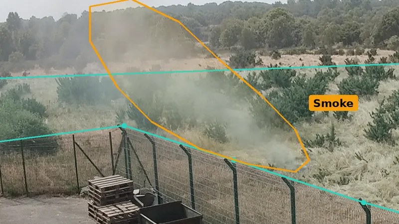
Cameras can add to that, because many sites near open land already have them on the fence, looking out over the boundary, usually for security. With AI detection added, a camera that can see the land next door watches for smoke and flame on that view all day and all night, and sends an alert with a short clip when it sees something. It is important to be clear about what this does and does not do. It does not replace the fire risk assessment, the firebreaks, the emergency plan or anything else in this guide. It cannot see a fire it has no view of, behind a hill, a hedge or a plantation, or in thick fog. What it adds is early sight of smoke, flame or someone in the wrong place, at any time, on land nobody is watching.
Where to put cameras at a site boundary
Many sites with cameras already have some that look along or over the fence. The question is whether those views are good enough, by day and at night, to see smoke starting on the land that matters most.
- Look outwards over the land next door. A camera high on a pole or a building, looking out across the field, heath or slope towards the prevailing wind, sees smoke rising long before the fire reaches the fence.
- Cover the stores and stockpiles near the fence. A view of the pallets, stockpiles, skips or fuel stores closest to the boundary sees embers taking hold inside the site.
- On solar farms, look down the rows. A camera on the security fence looking along the panel rows sees smoke from the grass underneath them.
- On holiday parks, watch the back row. A view along the caravans or lodges nearest the heath or forest covers both the guests and the land behind them.
- Think about night. Check every view after dark. Infrared or low-light cameras matter, and so does avoiding glare from floodlights or vehicle headlights.
Data protection law applies to CCTV. The ICO publishes guidance for organisations covering installation, operation, public awareness and signage, and the government’s Surveillance Camera Code of Practice sets out good practice principles. Cameras that look beyond your boundary need particular care: aim them at the land you need to watch, avoid neighbouring homes, gardens and public footpaths where you can, use signs, and say why you need the view in your data protection assessment. Our guide to AI CCTV and GDPR in the UK covers this in more detail.
Polygon zones: drawing round the land that matters
A camera looking out over open land sees a lot: the sky, the road, the neighbour’s house, the trees moving, the shadows of clouds. AI detection works best when you tell it exactly where to look. With polygon detection areas you draw a shape that follows the edge of the field, the strip of heath, the grass between the panel rows or the top of a stockpile, rather than a rough box that takes in the road or the sky. Smoke inside that shape triggers an alert; movement outside it does not. You can draw several zones on one camera, and a line along a firebreak track or the foot of the fence.
Detection schedules: smoke all the time, people at night
Different kinds of detection suit different times. Smoke and flame detection over the land next door, the stores and the panel rows should run all day and all night, because a wildfire can start at any time, and several of the 2026 fires started in the middle of the day. People and line detection is useful after dark, but would alert constantly during the day when staff, walkers, guests and vehicles are about.
A typical arrangement is smoke over the land next door, at the stores and down the solar rows on all the time, with a line along the heath edge and a people zone at the boundary armed from, say, 20:00 to 06:00. Every site is different, and schedules should follow how yours actually works, including early shifts, late events, and summer evenings when guests are out on the heath.
When the alert comes in
An alert is only as good as what happens next. Decide in advance who receives alerts for each camera, what they should do, and who they should call. On a small site that might be two or three phones. On a holiday park, it might be the duty manager and the warden on call. On a solar farm with nobody on site, it might be the operations team and a local contact who can get there. Write it down and test it.
- Check the clip. Look at the snapshot and the short clip with the alert. Is it smoke, or dust, mist or a bonfire you knew about? Where is it, how big, and which way is it moving?
- Call 999. If there is a fire, call the fire service straight away. Give the access point, what is burning, what is near it, and any access or water problems.
- Start the plan. Warn the people on site, move them to the safe zone or off site if needed, and shut down what you planned to shut down.
- Meet the crews. Send someone to the access point to meet the fire service, with the site plan, and show them the clip if it helps.
- Keep watching. Use the cameras to follow the fire and the smoke, and tell the crews if it changes direction or flares up again.
Smoke, dust and mist
Open land throws up things that can look like smoke: dust blowing off a track or a dry field, mist lying in a valley at dawn, steam, pollen or the exhaust of a tractor. Even fire services meet this: after the New Forest fire, Hampshire and Isle of Wight Fire and Rescue Service said recent reports of smoke were thought to be no more than dust and debris carried by the wind. Woodcock AI is self-learning, so it gets better at telling the normal from the unusual on each camera over time, and at telling real smoke from the dust and mist that is normal for that view.
What insurers look for
Commercial insurers are paying more attention to wildfire, and in August 2026 the government asked them to process claims from affected households and businesses as quickly as possible. Lancashire Fire and Rescue Service tells businesses to review their commercial property insurance to make sure it covers wildfire damage. Expect questions about what is next to your site, whether stores and stockpiles are kept back from the fence, whether you have an emergency plan and a business continuity plan, and how a fire on the land next door would be found out of hours.
Good records help: the fire risk assessment with its wildfire section, mowing and firebreak records, the emergency plan and when it was practised, and the detection arrangements. For more, see our guides to outdoor fire detection and what insurers expect from fire detection.
A wildfire risk assessment checklist
Use this checklist as a starting point. It does not replace a fire risk assessment, and the right precautions for your site depend on the land around it, what you store and who is there. The table summarises the main parts of a site covered in this guide.
| Area | Main risk | First steps | What cameras and AI add |
|---|---|---|---|
| Land next door | Grass, gorse or heath fire running to the fence | Map it, talk to the owner, agree a firebreak | A smoke zone over the land, always on |
| Boundary strip | Fire jumping into the site | Mown buffer, cuttings removed, nothing stacked at the fence | A line along the fence after dark |
| Stores and stockpiles | Embers landing on fuel | Move them back from the fence, cover where you can | Smoke zones drawn round each one |
| Machinery and hot work | Sparks into dry grass | No hot work outside on dry days, water nearby | Smoke seen in minutes after work stops |
| Visitors and public land | BBQs, campfires, cigarettes, arson | Clear rules, signs, patrols on dry days | People zones on the heath edge at night |
| People on site | Smoke, blocked routes | Two routes out, a safe zone, a practised plan | Clips showing where the fire is |
| Fire service | Finding the fire, access, water | what3words for access, someone to meet crews, water mapped | A clip to show crews on arrival |
- Does your fire risk assessment cover a fire coming in from open land, and has it been reviewed since summer 2026?
- Have you mapped the land around the site, its fuel, the slope, the prevailing wind and where people stop?
- Do you know who owns and manages the land next door, and have you talked to them about firebreaks and smoke?
- Is there a mown buffer at the boundary, with cuttings removed, and a firebreak beyond it that is kept up through the season?
- Are pallets, skips, stockpiles, fuel and vehicles kept back from the fence and off dry grass?
- Are mowing, machinery and hot work planned for safer times, with water nearby and checks afterwards?
- Do visitors and guests know the dry-weather rules on barbecues, fires and cigarettes, and is there a PSPO in your area?
- Do you have triggers for stepping up on high fire danger days, and are staff signed up for alerts?
- Is there a written wildfire emergency plan with two routes out, a safe zone, named people and a way to reach guests?
- Would the fire service find your access point, and do you know where water is?
- Is there a business continuity plan and insurance cover for wildfire damage and disruption?
- Who would notice smoke on the land next door at 3pm on a busy day, or at 3am, and how quickly?
How Woodcock AI helps with wildfire risk
Woodcock AI connects to existing IP cameras over RTSP or ONVIF and runs on an edge server on site or on a cloud server. It adds smoke, flame, people and vehicle detection to the cameras you already have. You draw polygon zones that fit the shape of the land next door, the grass between the panel rows or the stockpiles by the fence, rather than a rough box, draw lines along the heath edge and the firebreak track, and set schedules so smoke detection runs all day and night while security zones are armed only after dark. When something happens, an alert with a snapshot and short clip goes to the phones of the people you choose, and an AI description says what the camera saw.
Woodcock AI is self-learning, so it gets better over time at knowing what is normal on each camera, such as dust off a track, mist at dawn or a tractor in the next field. It is the result of years of development and is now in use on real sites in the UK. It watches for smoke, flame and people on the views your cameras have: it cannot see over a hill or through a plantation, and it supplements rather than replaces the precautions in this guide. For how the same approach fits particular kinds of site, see our pages on solar farms and battery storage, holiday park security, quarry security and farm fire safety. Ask your cameras, a way to ask the system questions about what it has seen, is Coming soon, early 2027.
Ways to start
Start with a site assessment. We look at your boundary and the land around it, which cameras you have and what each one sees by day and at night, and show where smoke zones over the land next door, people zones and lines would help. Or ask for a live test on your cameras: we connect two or three of your existing cameras for about a fortnight, so you can see the alerts for yourself before deciding. We are also happy to arrange an on-site demo.
Sources
- legislation.gov.uk, Regulatory Reform (Fire Safety) Order 2005, Fire (Scotland) Act 2005 and Fire Safety Regulations (Northern Ireland) 2010; GOV.UK, Fire safety risk assessment: 5-step checklist.
- House of Commons Environment, Food and Rural Affairs Committee, A burning issue: managing wildfire risk, HC 713 (October 2026, PDF).
- Ministry of Housing, Communities and Local Government, Provisional wildfire statistics for England, 2010 to 2026; Home Office, Fire and rescue incident statistics: year ending June 2026 and Outdoor fires dataset guidance.
- Moorland Association, Bigger fires, stretched crews: 2026 breaks England’s wildfire records; Senedd Research, Wildfires in summer 2026: in brief; Global Wildfire Information System (GWIS), annual statistics for the United Kingdom; European Forest Fire Information System (EFFIS), annual statistics for the United Kingdom; The Guardian, Record number of wildfires in 2025 (December 2025).
- National Fire Chiefs Council, Wildfires position statement and Prepare and protect against wildfires.
- Lancashire Fire and Rescue Service, Protecting your business from wildfires; East Sussex Fire and Rescue Service, Wildfire advice for rural landowners.
- Met Office, Fire Severity Index.
- GOV.UK, Emergency Alert to be sent to England and Wales and Emergency Alert of 14 August 2026; BBC, disposable barbecue sales ban.
- Incident reports: Mid and West Wales Fire and Rescue Service (Cefn Bryn), Hampshire and Isle of Wight Fire and Rescue Service (Bagshot Moor), BBC (Peak District), Kent Fire and Rescue Service (Swanscombe), BBC (Cairngorms), Suffolk Fire and Rescue Service (Dunwich Heath) and BBC, BBC (Meden Vale), New Forest National Park Authority (New Forest) and BBC, BBC (Stourbridge cause) and BBC (Stourbridge homes and national alert), and BBC (Weston-super-Mare).
- Information Commissioner’s Office, CCTV and video surveillance, and GOV.UK, Amended Surveillance Camera Code of Practice (in effect from 12 January 2022).
We have summarised these sources in our own words. Wildfire figures vary between sources, definitions and periods, and the 2026 figures are provisional, so read the current versions in full. This page is general guidance, not a fire risk assessment, or legal or insurance advice; your fire and rescue service, fire risk assessor and insurer can advise on your own site. In an emergency, always call 999.
Would anyone see smoke on the land next door at 3am?
Book a site assessment and we will look at your boundary, the land around it and what your cameras can see by day and at night, and show where smoke zones, people zones and lines would help, or ask for a live test on your cameras.
Related pages
Frequently asked questions
What is a wildfire risk assessment?
It is an assessment of how a fire on open land near your site could start, spread and affect people and property, and what you will do about it. It looks at the land around you and its fuel, the slope and wind, ignition sources, who and what is at risk, and your plans for high fire danger days and an approaching fire. It is usually part of your wider fire risk assessment.
Is a wildfire risk assessment a legal requirement in the UK?
There is no specific UK law requiring one, and the EFRA Committee noted in 2026 that there is no general statutory duty to consider wildfire risk in land management. But workplaces must have a fire risk assessment under the Fire Safety Order 2005 or the Scottish and Northern Irish equivalents, and for a site near open land that should consider a fire coming in from outside. Planning policy now expects proportionate wildfire measures where the risk is high.
How wide should a firebreak be?
There is no single width that suits every site. It depends on the fuel next door, the slope, the prevailing wind and what you are protecting. The NFCC suggests a cleared zone of 5 to 10 feet round buildings and grass kept below about 7 cm, and fire services advise mown buffers and cut or ploughed breaks beyond. Ask your fire service, and check breaks through the season, as Dunwich showed breaks can prove insufficient.
What is the Fire Severity Index?
The Met Office Fire Severity Index assesses how severe a wildfire could become if one started, using weather data such as rainfall, drought, wind, temperature and humidity. It is updated daily and shown on Natural England’s open access website, and it is used mainly to decide whether to close open access land. It does not predict when or where a wildfire will start.
How many wildfires were there in the UK in 2026?
Figures depend on the definition. Provisional government figures analysed by the Moorland Association show 1,354 wildfires in England from January to August 2026, against 957 a year earlier, with 468 over 10,000 square metres. The EFRA Committee recorded 1,132 in England and Wales by 16 August, and the Global Wildfire Information System (GWIS) puts the UK area burned in 2026 at 28,299 hectares, the second highest on its record. The European Forest Fire Information System (EFFIS) ranks 2026 third, at 25,084 hectares.
Can CCTV detect a wildfire?
A camera can only see what is in its view, so it will not see a fire behind a hill or a plantation. But AI on cameras already on a site boundary can watch the land next door, stockpiles and solar rows for smoke and flame all day and night and send an alert with a clip. Woodcock AI runs on an edge server on site or on a cloud server and supplements, rather than replaces, a fire risk assessment.
Last reviewed 2 November 2026